Best Natural Wonders in Vietnam
Discover the radical tectonic history and fragile ecosystems behind the best natural wonders in Vietnam. From the colossal subterranean chambers of Son Doong to the volcanic cliffs of Ly Son Island, this authoritative guide delivers deep geological insights, accurate difficulty assessments, and vital eco-etiquette for the responsible modern adventurer.
Vietnam’s topography is a living textbook of radical tectonic history, sculpted over hundreds of millions of years of continental collisions, marine transgressions, and intense karstic erosion. From the fractured granite blocks of the northern alpine frontiers down to the flooded subterranean networks of the central provinces, the country's physical architecture is defined by its dramatic diversity. This complex landscape is the direct result of massive structural movements along regional fault lines, which lifted ancient sea beds into the sky and left behind some of the most intricate limestone, basalt, and volcanic formations on Earth.
In recent years, the paradigm of modern travel in Vietnam has undergone a profound shift. Visitors are no longer content with passive sightseeing from the windows of a tour bus; there is a growing demand for immersive, education-driven exploration. Discerning travelers seek to decode the ancient origins of these ecosystems, moving through them with a heightened sense of ecological responsibility. Exploring Vietnam’s wilderness is now an exercise in low-impact adventure, where understanding the fragility of a landscape is just as crucial as witnessing its grandeur.
Vietnam’s Natural Wonders At A Glance
- Son Doong Cave (Karst Cave System)
- Difficulty Tier: Extreme
- Fragility & Conservation Rule: Strictly limited permits are enforced annually. Travelers must adhere to zero-trace camping protocols and are strictly forbidden from touching any speleothems or delicate calcite formations.
- Ha Long & Lan Ha Bays (Fengcong & Fenglin Karst)
- Difficulty Tier: Easy to Moderate
- Fragility & Conservation Rule: Bound by strict maritime waste regulations and a comprehensive single-use plastic ban. Watercraft must follow designated kayak pathways to protect marine habitats.
- Trang An Complex (Transgressive Karst Valley)
- Difficulty Tier: Easy
- Fragility & Conservation Rule: Navigation is restricted to hand-paddled boats only to eliminate fuel emissions. Mandatory trash retrieval is required, and access to avian nesting zones is heavily restricted.
- Ban Gioc Waterfall (Tufa/Travertine Cascade)
- Difficulty Tier: Easy
- Fragility & Conservation Rule: Subject to international border zone regulations. Swimming near the main plunge pools is strictly prohibited to preserve protected riparian buffers.
- Ly Son Island (Volcanic Neogene/Quaternary)
- Difficulty Tier: Easy to Moderate
- Fragility & Conservation Rule: Regulated under Marine Protected Area (MPA) rules. Visitors must follow strict coral preservation guidelines and limit their freshwater usage on the island.
Subterranean Kingdoms: Vietnam’s Colossal Cave Systems
Son Doong & The Phong Nha-Ke Bang Karst Network
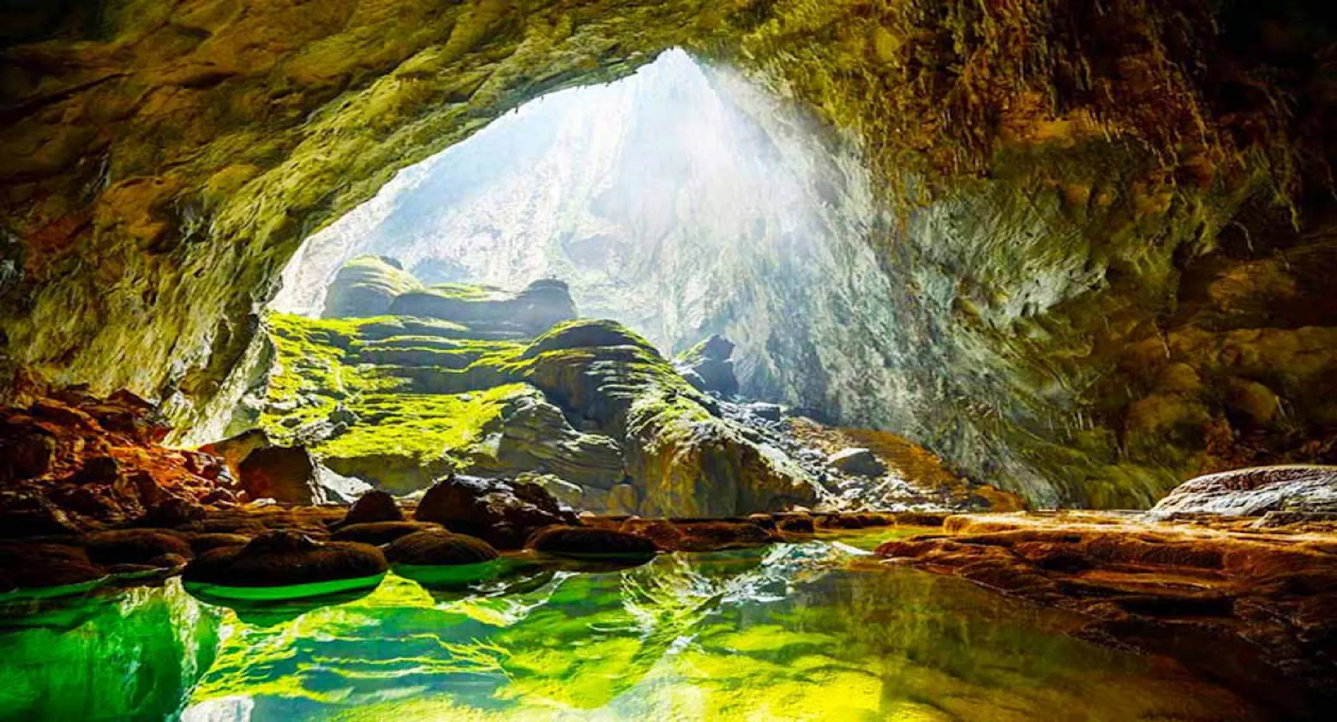
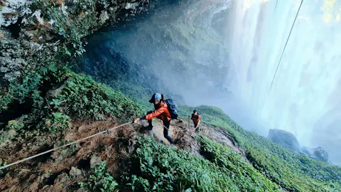
The Phong Nha-Ke Bang National Park houses the apex of terrestrial dissolution topography: Son Doong Cave. Formed between 2 and 5 million years ago by the relentless carving action of an underground river through pure Paleozoic limestone, this colossal cavern stands as the largest natural cave passage on Earth.
The physical dimensions of Son Doong defy standard logic, stretching over 5 kilometers in length with sections reaching up to 200 meters high and 150 meters wide. Its most defining features are its massive dolines—vast structural collapses where the cave ceiling caved in long ago, allowing sunlight to penetrate the deep subterranean world.
These light shafts have catalyzed the growth of a self-contained jungle ecosystem known as the "Garden of Edam," home to endemic adapted organisms, flying foxes, and monkeys. The cave's immense volume creates its own localized atmospheric shifts, generating internal weather systems complete with swirling subterranean clouds that condense near the ceiling.
For travelers unable to secure the highly competitive permits or endure the demanding physical trek required for Son Doong, the Phong Nha network offers exceptional, accessible alternatives. Paradise Cave (Dong Thien Duong) showcases a stunning display of dry cave speleothems along an easily navigable wooden boardwalk.
For those seeking a taste of raw exploration, the Tu Lan Cave System offers a modular multi-day adventure involving river swimming and technical trekking through wild, unlit chambers.
- Fitness & Access Check: Expeditions into Son Doong require an Extreme Adventure Tier rating. Participants must endure multi-day jungle treks, vertical rope ascents, and technical bouldering. Access is strictly capped at less than 1,000 visitors per year, managed by a single licensed operator, and requires booking up to a year in advance.
Where Karst Meets Water: Iconic Aquatic Landscapes
Ha Long Bay vs. Lan Ha Bay: The Marine Limestone Labyrinths
The surreal seascapes of the Gulf of Tonkin are defined by a classic fengcong (clustered peak) and fenglin (isolated tower) karst evolution. Over 500 million years of marine deposition, tectonic uplift, and aggressive tropical weathering, a vast limestone plateau was slowly carved into roughly 2,000 jagged islets and towers rising directly from the emerald waters.
While Ha Long Bay remains the historic focal point for this landscape, it suffers from heavy maritime congestion and concentrated environmental runoff. Travelers seeking a more pristine, eco-conscious alternative are turning south to Lan Ha Bay.
Geologically identical but far less impacted by large-scale cruise infrastructure, Lan Ha provides an authentic wilderness experience. The bay's tight network of islands creates secluded tidal lagoons accessible only via low-profile kayaking through narrow sea caves (locally called Luon caves).
These isolated ecosystems protect remnants of the region's original biodiversity, including the critically endangered Cat Ba langur (Trachypithecus poliocephalus), a white-headed primate restricted to these sheer limestone cliffs.
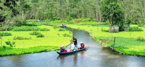
Ninh Binh: The Terrestrial Evolution of Trang An
Often termed the "Dry Ha Long Bay," the Trang An Landscape Complex in Ninh Binh showcases a later stage of karstic evolution, where the sea has retreated to leave a landscape of flooded inland valleys. Here, vertical limestone towers enclose flat, alluvial plains connected by an intricate web of subterranean river passages.
The human and ecological rhythm of this landscape is best viewed along the Ngo Dong River within the Tam Coc valley. The water levels fluctuate dynamically with the seasonal monsoon, while the valley floor transforms dramatically during the spring and summer rice harvests.
The golden agricultural ribbons contrast sharply with the dark, weathered gray of the 250-million-year-old limestone massifs. This harmonious intersection of ancient geology and traditional wet-rice cultivation forms the core of Ninh Binh’s UNESCO World Heritage designation.
Highland Frontiers & Powerful Waters
Ban Gioc Waterfall: The Multi-Tiered Border Wonder
Situated directly on the international border between Vietnam and China, Ban Gioc Waterfall is Asia’s largest transnational cascade. The waterfall is fed by the Quay Son River, which originates in China and cuts through a jagged karst valley before dropping over a massive limestone ledge in Trung Khanh District, Cao Bang.
The waterfall's unique structure relies on tufa (travertine) formations—sedimentary rock created when dissolved calcium carbonate precipitates out of the rushing water over thousands of years. This process has built a series of stepped, multi-tiered stone terraces and deep, jade-green plunge pools.
During the peak of the rainy season, these distinct tiers merge into a thunderous wall of water over 300 meters wide and 30 meters high, sending a dense, cooling mist across the surrounding riparian forests and bamboo groves.
The Volcanic Soul of Ly Son Island
Far removed from the limestone domains, Ly Son Island off the coast of Quang Ngai Province provides a stark window into Vietnam's Cenozoic volcanic past. The island is an accumulation of Neogene and Quaternary volcanic activity, composed almost entirely of dark basaltic rock and layers of compressed volcanic tuff.
The most dramatic manifestation of this geology is found at Hang Cau, where a massive, sheer cliff face reveals distinct horizontal strata of volcanic ash and sediment carved out by centuries of marine wave abrasion.
The rim of the island’s ancient craters, such as the Thoi Loi Mountain caldera, offers panoramic views of the island's unique agricultural grid, where garlic fields are cultivated in a specialized mixture of crushed volcanic basaltic soil and mineral-rich sea sand.
Offshore, the island's fringing reef systems thrive on the hard, stable basalt substrates, creating a vital sanctuary for marine biodiversity.
Preserving the Wilderness: Eco-Etiquette for Travelers
To maintain the ecological integrity of these ancient sites, visitors must transition from casual tourists to active preservationists. Below are the critical environmental threats and their direct, actionable alternatives:
- Cave Speleothems & Stalactites
- The Human Threat: Oils and sweat from human skin instantly halt mineral deposition and permanently stain pure calcite structures.
- The Low-Impact Solution: Never touch cave walls or formations. Maintain a strict 1-meter buffer zone even when navigating narrow passages.
- Marine Fringing Coral Reefs
- The Human Threat: Chemical oxybenzone found in traditional sunscreens causes severe bleaching; dragging boat anchors smashes centuries-old delicate reef structures.
- The Low-Impact Solution: Use exclusively reef-safe, mineral-based sunscreens (Zinc Oxide or Titanium Dioxide). Ensure your tour operators utilize fixed mooring buoys.
- Estuarine & Coastal Waters
- The Human Threat: Plastic ingestion by vulnerable marine life and dangerous microplastic breakdown inside closed bay systems.
- The Low-Impact Solution: Pack out all single-use plastics. Utilize reusable aluminum flasks and support cruise operators that utilize certified gray-water filtration.
- Terrestrial Jungle Canopy
- The Human Threat: Excess noise pollution and tourist feeding alter natural wildlife behavior and disrupt sensitive nesting cycles.
- The Low-Impact Solution: Maintain absolute silence on jungle trails. Never feed wild animals; utilize telephoto lenses to observe safely from a distance.
Vietnam's natural wonders are far more than scenic backdrops; they are ancient, fragile ecosystems that have been meticulously sculpted over hundreds of millions of years of geological history. The privilege of entering these ancient subterranean kingdoms, paddling through tidal karst labyrinths, and standing before volcanic cliffs carries an absolute responsibility of stewardship. By adopting low-impact travel habits, choosing eco-certified operators, and respecting strict conservation boundaries, travelers ensure these geological masterpieces remain entirely undisturbed for generations to come.
Frequently Asked Questions
Vietnam’s karst topography is the product of tropical karstification. Between 400 and 250 million years ago, the region was covered by a warm, shallow sea, depositing immense layers of calcium carbonate. Subsequent tectonic collisions lifted these limestone plates. The combination of heavy tropical rainfall and abundant organic acids in the jungle soil created a weak carbonic acid solution. As this water percolated through fractures in the uplifted limestone bedrock, it dissolved the rock along its joints, slowly creating the distinct towers, dolines, and cave networks seen today.
Due to a strict environmental quota of under 1,000 visitors per year, expeditions to Son Doong must be booked 6 to 12 months in advance. Vetting is managed via a mandatory medical and physical questionnaire. Applicants must demonstrate regular rucking or trekking experience, the ability to ascend steep vertical inclines, and comfort walking through deep water and unlit terrains.
The Trang An Landscape Complex in Ninh Binh and Paradise Cave in Phong Nha are highly suited for individuals with limited mobility. Trang An features low-sided, stable rowboats where guests sit comfortably while local guides paddle through flat valleys, minimizing physical exertion. Paradise Cave features a 1-kilometer interior wooden boardwalk equipped with handrails and gentle inclines, avoiding rough, unpaved cave floors.
The Southwest Monsoon (typically June to September) brings heavy rainfall that dramatically alters natural sites. At waterfalls like Ban Gioc, water volume peaks, creating spectacular cascades, though runoff can turn the water muddy brown. In cave networks, this season poses severe flash-flood risks; many deep cave systems close completely as water levels rise rapidly within subterranean passages. Conversely, the dry winter months (November to April) offer pristine water clarity and stable safety conditions, though waterfall volumes are visibly reduced.
Cuc Phuong National Park (Ninh Binh): Vital for spotting the critically endangered Delacour's langur and visiting specialized primate and turtle rescue centers. Cat Ba National Park (Hai Phong): The exclusive sanctuary of the remaining wild Cat Ba langurs, visible along sheer coastal cliffs. Phong Nha-Ke Bang National Park (Quang Binh): Home to rare macaques, serows, and the elusive Saola within its dense primary rainforest blocks.
Navigating high-altitude routes during the rainy season carries significant risk and requires caution. Heavy monsoonal downpours often trigger sudden landslides along steep vertical cuts and generate dense, blinding fog layers that reduce visibility to less than 5 meters. For a much safer and highly enriching alternative, travelers can experience the region via the "Hanoi 5 Gates" cultural tourism train. Launched as a premier heritage rail experience, this double-decker train features unique carriages named after the ancient gates of Thang Long—including O Quan Chuong and O Dong Mac. The route runs from Hanoi Station across the historic Long Bien Bridge to Tu Son in Bac Ninh, providing panoramic views of the shifting northern landscape and traditional live performances like Quan Ho folk singing, completely bypassing the hazards of rainy mountain roads.
Everything you need for your Vietnam adventure
Find places to stay
Discover hotels, resorts and unique stays in Vietnam.
- Best price guarantee
- Wide range of options
- Free cancellation options
Please choose app:
Explore experiences
Book local tours, activities and unforgettable experiences.
- Handpicked experiences
- Free cancellation
- Trusted local partners
Please choose app:
Plan your journey
Compare flights, trains and transport options across Vietnam.
- Best fare options
- Multiple transport choices
- Secure booking
Please choose app:
We may earn a commission when you book through the links above. This helps support Go Visit Vietnam at no extra cost to you.

Join our Newsletter Clan
Get VietNam inspiration direct to your inbox. Don't miss the inside track from our VietNam experts on exciting trip ideas, unique attractions and hidden gems loved by locals.