
Best Places to Visit in Cao Bang
Cao Bang is one of Vietnam's most spectacular northern provinces, famous for dramatic limestone mountains, cascading waterfalls, peaceful rivers, and rich ethnic minority culture. Home to the magnificent Ban Gioc Waterfall, the historic Pac Bo area, and breathtaking caves, Cao Bang offers unforgettable experiences for nature lovers and adventure seekers alike. This guide highlights the best places to visit in Cao Bang, helping you discover its natural wonders, cultural landmarks, and hidden gems for an unforgettable journey.

On this page
- The Crown Jewel: Ban Gioc Waterfall and Border Wonders Among the Best Places to Visit in Cao Bang
- Subterranean Marvels and Karst Mysteries: Exploring the Best Places to Visit in Cao Bang
- High-Altitude Lakes and Historical Sanctuaries: Essential Best Places to Visit in Cao Bang
- Practical Field Logistics for the Best Places to Visit in Cao Bang
- Finalizing Your Expedition to the Best Places to Visit in Cao Bang
To stand at the rugged, northernmost frontiers of Vietnam is to witness a dramatic, untamed landscape where jagged limestone karst peaks rise like ancient guardians above the emerald-green currents of deep mountain valleys. This formidable topography, sculpted by millions of years of tectonic activity and relentless hydrological forces, sets the stage for discovering the best places to visit in Cao Bang. Often relegated to a mere scenic stop on the standard Northern Vietnam motorcycle loop, this province is, in reality, a profound geological masterpiece and a living repository of revolutionary history that demands incredibly slow, thoughtful exploration. A meticulously planned Cao Bang travel guide must look beyond the superficial aesthetics of the frontier to understand the deep, indigenous ethnic culture that has thrived within these isolated karst corridors for millennia. From the thundering, transnational waters dividing empires to the silent, subterranean caverns echoing with the slow drip of calcium carbonate, identifying the premier Cao Bang tourist attractions requires a traveler to engage deeply with the terrain. This is an environment that strictly rewards the deliberate geographer and the curious historian, offering unparalleled access to a region where natural monumentality and intense national heritage inextricably intertwine.
The Crown Jewel: Ban Gioc Waterfall and Border Wonders Among the Best Places to Visit in Cao Bang
Thac Ban Gioc: The Majestic Boundary Falls
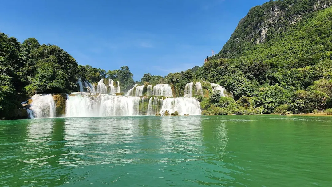
No comprehensive expedition to this northeastern province is complete without embarking on a dedicated Ban Gioc waterfall trip. Recognized officially as Thác Bản Giốc, this monumental cascade stands proudly as Southeast Asia’s most awe-inspiring transnational waterfall, a staggering geological fault line where the powerful Quay Son River drops drastically across a series of broad, calcified terraces. When evaluating the best places to visit in Cao Bang, this site demands absolute priority due to its immense hydrological scale and striking visual composition. Capturing the true grandeur of the falls requires a sophisticated understanding of seasonal water flows. During the aggressive summer monsoon months, the river swells violently, transforming the multi-tiered cascades into a singular, roaring curtain of turbulent white water that projects a massive plume of mist across the entire valley. Conversely, exploring the site during the dry autumn reveals a highly stratified, delicate series of crystalline pools, where the emerald waters step gracefully over the limestone bedrock. The expertise of the landscape photographer is tested here, as the shifting sunlight continuously alters the visual depth of the cascading tiers, highlighting the intense, vibrant green mosses that cling desperately to the vertical limestone faces beneath the crushing weight of the river.
The Surrounding Border Ecosystem
The geographical context of the waterfall further elevates its status as a premier destination, situated precisely on the sensitive international boundary demarcating Vietnam and China. This unique geopolitical and ecological environment creates a fascinating study in riparian biodiversity and cross-cultural geography. The visual contrast found along the riverbanks is stark and deeply evocative; the roaring white waters at the epicenter of the fault violently disrupt the otherwise tranquil, bamboo-lined banks that stretch peacefully into the distance. On the Vietnamese side, lush agricultural plots cultivated by the local Tay ethnic minority slope gently toward the water's edge, demonstrating a harmonious, centuries-old agraro-ecological adaptation to the unpredictable flooding cycles of the border watershed. Navigating these waters via a small bamboo raft allows the dedicated geographer to directly experience the sheer kinetic force of the plunging currents while observing the stark, towering karst monoliths that enclose the valley in a natural, impenetrable fortress. This delicate transnational ecosystem, where extreme hydrological power meets silent, agrarian resilience, provides a profoundly layered environmental narrative that standard tourism completely fails to articulate, cementing its reputation as a mandatory cornerstone of any serious frontier expedition. The Quay Son River itself acts as the primary architect of this entire valley, carving relentlessly through the soft sedimentary rock to expose the ancient, hardened limestone core. The resulting riparian zone is a dense, hyper-oxygenated microclimate supporting endemic flora that thrives exclusively within the perpetual mist of the falls. This intense concentration of geological and ecological activity ensures that the environment remains dynamically alive, constantly reshaping the frontier.
Subterranean Marvels and Karst Mysteries: Exploring the Best Places to Visit in Cao Bang
Nguom Ngao Cave: The Sculpted Stone Palace
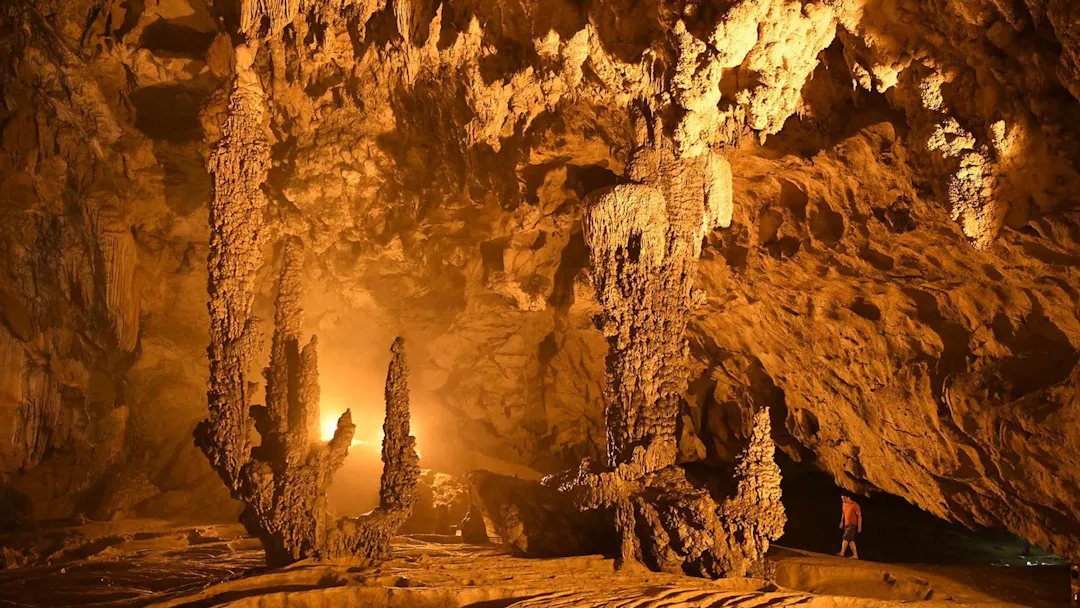
Transitioning from the deafening roar of the surface waterways, a rigorous Nguom Ngao cave exploration plunges the traveler directly into the silent, subterranean heart of the province. Locally designated as Động Ngườm Ngao, meaning "Tiger Cave" in the indigenous Tay dialect, this sprawling, multi-layered limestone cavern system is universally regarded as a masterpiece of subterranean architecture. For those documenting the best places to visit in Cao Bang, this specific cavern offers an unprecedented look into the slow, methodical artistry of water and time. Over millions of years, heavily mineralized groundwater has patiently seeped through the porous karst ceiling, depositing microscopic layers of calcite to form spectacular stalactites and stalagmites that defy conventional geometry. Unlike heavily commercialized caves elsewhere, the acoustic atmosphere inside this mountain remains deeply otherworldly and profoundly quiet, interrupted only by the rhythmic, echoing drip of active speleothem formation. The visual focal point of the expedition is the highly celebrated "lotus flower" formation, an inverted calcium carbonate structure that mimics the delicate petals of a blooming flower, engineered entirely by the precise, downward flow of ancient subterranean rivers.
The Geological Significance of the Global Geopark
The sheer complexity of this cavern system is entirely symptomatic of the broader regional geology, directly justifying the province's prestigious designation as the Non nước Cao Bằng UNESCO Global Geopark. Analyzing why this landscape holds such an esteemed international status requires framing the vast karst topography not merely as a scenic backdrop, but as a living, readable textbook of Earth’s evolutionary history. The geological stratification visible throughout the geopark chronicles over five hundred million years of tectonic uplifts, oceanic regressions, and intense tropical weathering. The massive limestone towers that dominate the horizon, technically classified as mature tropical fengcong and fenglin karst landscapes, are the heavily eroded remnants of an ancient, prehistoric seabed. By physically traversing these deep cavernous faults and observing the exposed bedrock, the intrepid geological tourist actively engages with the raw, tectonic forces that violently shaped the Southeast Asian peninsula. This immense scientific value transforms a simple sightseeing excursion into a rigorous academic field study, ensuring that every sheer cliff face and deep, echoing void contributes to a massive, ongoing narrative of planetary evolution and relentless geographical metamorphosis. The intricate network of underground fault lines also dictates surface hydrology, acting as a natural filtration system that regulates the flow of prominent rivers. Understanding this delicate subterranean plumbing is critical for appreciating the highland ecosystem, elevating the traveler's perspective to informed environmental stewardship.
High-Altitude Lakes and Historical Sanctuaries: Essential Best Places to Visit in Cao Bang
Thang Hen Lake Complex: The Emerald Mountain Eyes
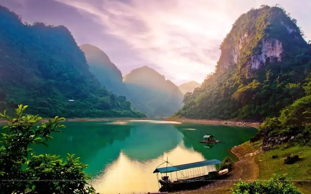
Ascending into the upper elevations of the Tra Linh district reveals the Thang Hen lake scenic area, a remarkable hydrological anomaly that stands in stark contrast to the surrounding jagged peaks. Known natively as Hồ Thang Hen, this site comprises an interconnected system of thirty-six high-altitude mountain lakes set precisely within a deeply sunken karst basin. When cataloging the best places to visit in Cao Bang, this complex is utterly indispensable for its serene, atmospheric beauty and its complex geological mechanics. Surrounded by dramatic, conical karst peaks draped in dense primary forest, the lakes are fed by a highly complex network of subterranean aquifers. This unique underground hydrological phenomenon acts as a natural purifier, filtering water through miles of limestone bedrock before it emerges into the basin, creating the striking, mirror-like clarity and vibrant azure hue of the surface water. During the intense dry season, the water levels experience a dramatic, sudden drawdown—a classic karst window phenomenon—where the lake drains back into the subterranean void, only to rapidly refill with the onset of the monsoons. Navigating the perimeter of the primary lake during the early morning hours, when a thick, chilling mist rolls off the cold surface waters and actively obscures the towering limestone sentinels, provides a profoundly introspective, solitary experience that sharply contrasts with the kinetic energy of the province's massive waterfalls.
Pac Bo Historic Site: The Cradle of Revolution
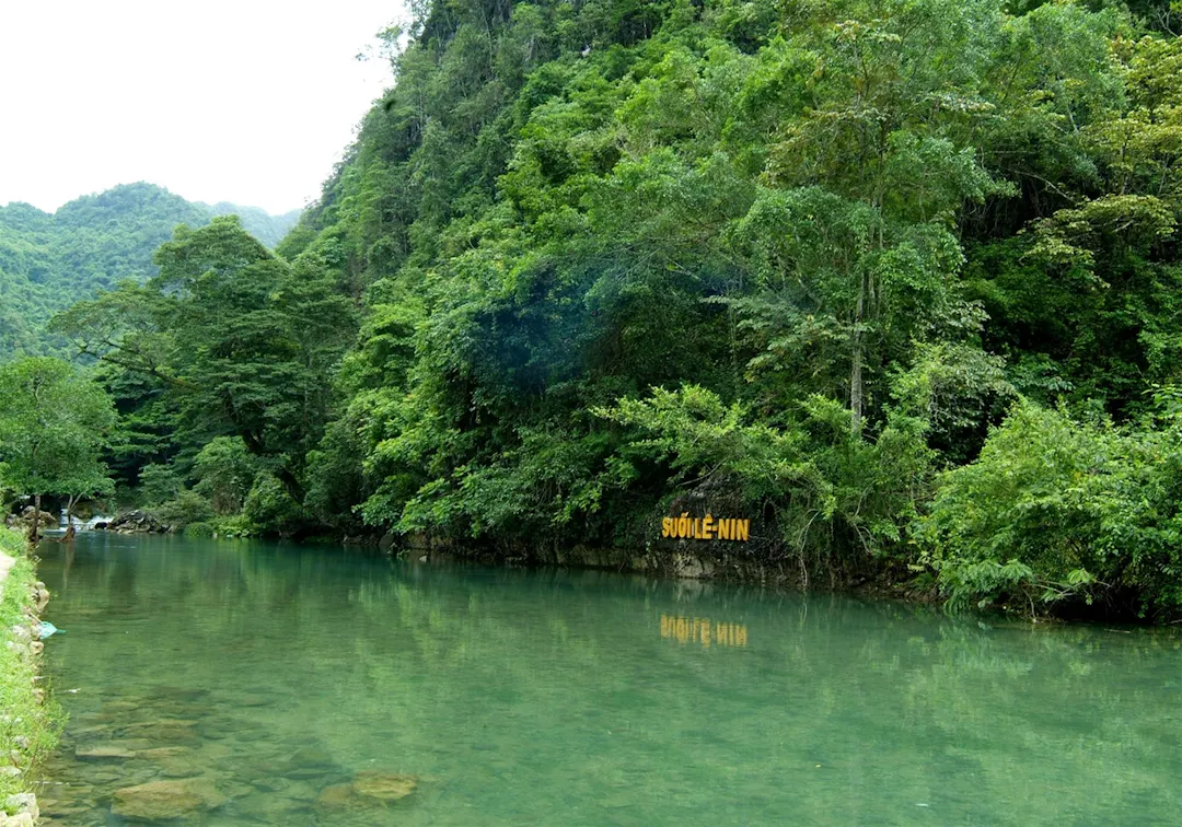
The geological isolation of these northern mountains historically provided an impenetrable natural fortress, a tactical advantage that fundamentally altered the trajectory of modern Southeast Asian history at the Pác Bó historical site. Recognized universally as the absolute cradle of the Vietnamese revolution, this deeply revered sanctuary offers profound historical context seamlessly blended with staggering natural serenity. In 1941, after three decades of international exile, Ho Chi Minh crossed the heavily guarded Chinese border and established his clandestine headquarters within the damp, concealed confines of the Coc Bo cave. The site is geographically anchored by the towering limestone mass of Karl Marx Mountain and the fiercely flowing, impossibly clear waters of the Lenin Stream. The intense, almost electric blue coloration of the stream, resulting from highly dissolved limestone minerals, provides a striking visual focal point against the dark, dense jungle canopy. Visiting this location requires adopting a posture of deep historical reverence. To walk the precise, moss-covered stone pathways alongside the riverbank where modern Vietnamese independence was meticulously strategized is to physically touch the very epicenter of the nation's contemporary identity. By preserving the original stone table where revolutionary manifestos were drafted, the site bridges the immense gap between raw geological time and the rapid, volatile pace of twentieth-century geopolitical transformation.
Practical Field Logistics for the Best Places to Visit in Cao Bang
Navigating Mountain Passes and Remote Roads
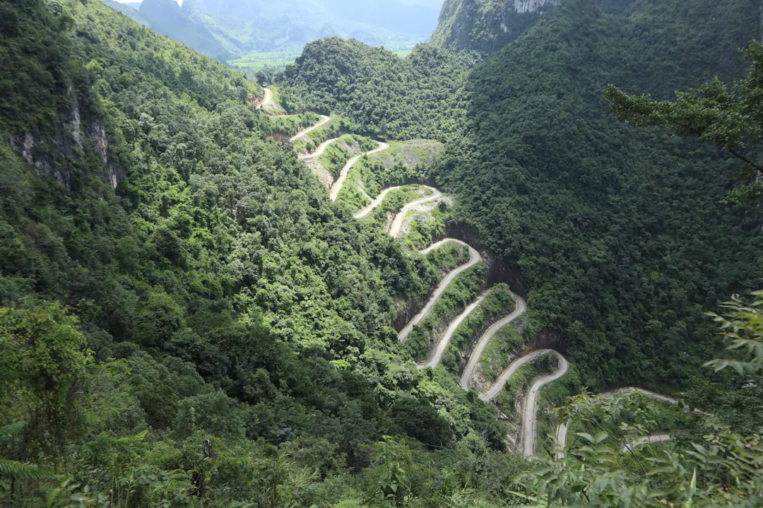
Executing a successful expedition to these remote, high-altitude coordinates requires rigorous logistical preparation and an acute awareness of the demanding frontier infrastructure. Navigating the province’s notorious, winding mountain passes, most notably the towering Ma Phuc Pass with its formidable seven-tiered incline, demands the utilization of highly experienced local drivers. The severe, undulating topography necessitates the use of reliable 4WD vehicles or heavily maintained motorbikes. The steep gradients and frequent hairpin turns are frequently subjected to sudden fogs and unpredictable rockfalls. Furthermore, careful seasonal timing is absolutely paramount to ensure both physical safety and optimal visual clarity. Attempting to traverse these isolated border roads during the peak monsoon season in July and August exposes travelers to severe flash flooding and catastrophic landslides that sever critical supply routes. The authoritative traveler must strategically target the dry autumn months of October and November, when monsoon hazards have subsided, skies offer maximum visibility for landscape documentation, and perilous dirt tracks have solidified sufficiently for safe passage.
Cultural Etiquette in Ethnic Communities
Beyond the intense physical navigation of the landscape, operating ethically within this isolated territory requires strict adherence to localized cultural protocols. The vast majority of the UNESCO geopark is stewarded by traditional Tay, Nung, and Hmong ethnic minority communities, who reside in ancient, wooden stilt houses perched precariously along the limestone ridges. Travelers must prioritize deep trustworthiness and responsible tourism practices when entering these localized spheres. Always request explicit, verbal permission before documenting village life or photographing indigenous individuals, particularly the elderly artisans engaged in traditional indigo dyeing or blacksmithing. When invited into a local stilt house, it is mandatory to remove your footwear and avoid pointing the soles of your feet toward the family altar, a deeply ingrained sign of spiritual disrespect. By consciously supporting local homestays and purchasing handcrafted textiles directly from the village weavers, the conscientious traveler ensures their economic footprint actively sustains the fragile, intangible cultural heritage that defines the human element of this magnificent northern frontier.
Finalizing Your Expedition to the Best Places to Visit in Cao Bang
Ultimately, traversing this formidable northern province offers one of the most intellectually stimulating, historically profound, and visually striking journeys in Southeast Asia. By actively engaging with the intense geological stratifications and respecting the resilient indigenous cultures, you elevate your expedition far beyond standard tourism. Choosing the best places to visit in Cao Bang is not merely about plotting a route; it is about immersing yourself in a living testament to Earth's sheer tectonic power and human endurance. Which monumental landmark—the thundering majesty of the Ban Gioc waterfall or the echoing mystery of the Nguom Ngao cave—are you most prepared to document first on your upcoming frontier expedition?
Read more: Cao Bang Travel Guide

By Roy Trinh
Editor
Roy Trinh is a travel writer and destination expert at Go Visit Vietnam, dedicated to helping travelers discover the beauty, culture, and diversity of Vietnam. Through well-researched travel guides, practical itineraries, local insights, and authentic recommendations, Roy shares valuable information to inspire memorable journeys across the country. From vibrant cities and breathtaking landscapes to regional cuisine and cultural heritage, every guide is created to help visitors experience Vietnam with confidence and curiosity.
Frequently Asked Questions About Visiting Cao Bang
What is the most famous attraction in Cao Bang?
The province's most iconic landmark is Ban Gioc Waterfall, one of the largest and most beautiful waterfalls in Southeast Asia. It sits on the Vietnam–China border and is renowned for its stunning scenery throughout the year.
How many days should I spend in Cao Bang?
A 2–4 day itinerary is ideal. This allows enough time to visit Ban Gioc Waterfall, Nguom Ngao Cave, Pac Bo Historic Site, local ethnic villages, and enjoy the province's scenic mountain roads.
Is Cao Bang suitable for independent travelers?
Yes. Cao Bang is an excellent destination for independent travelers, especially those who enjoy road trips and outdoor adventures. Renting a motorbike or hiring a local driver offers the greatest flexibility for exploring remote attractions.
What are some lesser-known places to visit in Cao Bang?
Beyond Ban Gioc Waterfall, visitors should consider exploring Nguom Ngao Cave, Pac Bo Historic Site, Thang Hen Lake, Phia Oac–Phia Den National Park, and traditional villages inhabited by the Tay and Nung ethnic communities.
Is Cao Bang worth visiting compared to other northern provinces?
Absolutely. Cao Bang offers a unique combination of spectacular natural scenery, fascinating history, peaceful rural landscapes, and authentic ethnic culture. It is less crowded than many popular destinations, making it an excellent choice for travelers seeking a more authentic experience in northern Vietnam.
Advertising box